Updated 9th May - Covering 13th May - 4th June 2024
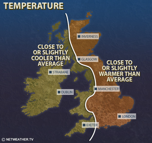
Relative to the 1991-2020 long-term average, temperatures will be less than 1C above normal in Northern Ireland, south Wales and south-west England, but 1 to 2C above normal elsewhere.
Rainfall totals will be above normal in most regions, particularly in the south-west, but northern Scotland may see near or slightly below average rainfall.
Sunshine totals are expected to be below normal for most, especially again in south-western Britain, but in northern and eastern Scotland and eastern England they may come out not far from normal, and parts of northern Scotland may end up sunnier than average.
While a spell of high pressure is expected during the preceding week, it looks probable that the high pressure will move away to the north-east of Britain during Week 2, allowing a pattern to develop that has been familiar during late 2023 and early 2024, with low pressure often centred to the south-west of Britain, bringing frequent rain or showers especially to the west and south.
High pressure will keep the weather relatively dry and settled in Scotland early in the week, and western Scotland is likely to be warm and sunny, but low cloud and suppressed temperatures will affect eastern Scotland due to easterly winds. Wetter weather will extend northwards into Scotland during the second half of the week. Elsewhere, it will be changeable with some bands of rain moving from south-west to north-east, and brighter weather with showers in between the rain bands, and there is potential for some thunder, particularly in the south of Britain. With winds tending to blow from the south-east, and probably turning southerly late in the week, temperatures are nonetheless expected to be above the seasonal average, except in north-eastern coastal counties due to onshore winds. South-western Britain and Northern Ireland may also see closer to average temperatures due to being close to the low pressure centres, but central and eastern England will frequently be warm despite the frequent rain. As noted earlier western Scotland will also be notably warm at times.
Mean temperatures are thus forecast to be 1 to 2C above the 1991-2020 long-term normal in most regions, but probably up to 3C above in inland parts of central and eastern England and in western Scotland. Temperatures may be less than 1C above normal in coastal areas of eastern Scotland and north-east England, and in Northern Ireland, south Wales and south-west England.
It will be wetter than average in most parts of the UK, especially in south Wales and southern England, but drier than average in northern Scotland.
Sunshine totals are expected to be above normal in north-west Scotland, but probably below normal in most other parts of the UK, although there is more uncertainty over sunshine amounts, for if frontal systems and associated persistent rain push through overnight, some areas of the UK may see a lot of bright and showery weather and consequently near or slightly above average sunshine. However, confidence is quite high that south-western Britain will be cloudier than normal.
It looks set to remain wet but rather warm, but with some shifts in the pressure patterns, with lowest pressure becoming centred to the west and north-west of Britain, resulting in frequent southerly and south-westerly winds. This means that the driest weather will often be in the north and east of Scotland, sheltered from the south to south-westerly winds, and in these regions rainfall is expected to be near normal. Elsewhere it will tend to be wetter than average again, and the south-west of Britain is again especially likely to see frequent rain. Temperatures are expected to be above average, especially in the north and east of Britain, but potentially near average in south Wales and south-west England and in Northern Ireland. There is potential for brief hot thundery interludes to affect mainly southern and eastern parts of England. Sunshine may end up near or slightly above average in northern and eastern Scotland and eastern England, but it is likely to be somewhat cloudier than average again in south-western Britain.
Unsettled weather again looks likely to persist for much of the period, but as we head into June there is an increasing chance of the jet stream shifting further north and high pressure building from the south, resulting in an increasing chance of some predominantly warm dry sunny weather affecting the south and east of Britain, with the more unsettled conditions becoming more concentrated in north-western Britain. Overall, it is thus likely to be wetter than average in the north of Britain, with near average rainfall more likely for the south, and sunshine is most likely to be near or slightly below normal for most of the country. Temperatures will probably not be far from the long-term normal, with indications that we may lose the predominantly southerly winds, although for eastern England it is likely to be warmer than normal.
Monthly weather forecast
The month ahead forecast is written by Ian Simpson and is updated every Monday.