Yesterday saw everything but the kitchen sink thrown at us, with snow, large hail, gales, thunder & lightning. Today sees more sunshine but still windy with some sharp showers. Fortunately the weather looks to calm down over the weekend, with fewer showers, lighter winds and turning warmer.
Maundy Thursday saw everything but the kitchen sink and all seasons thrown at us weather-wise, except a heatwave. Snow, strong winds, heavy rain leading to flash-flooding, thunder and lightning and even large spiky hail falling from a suspected supercell over south Oxfordshire.
Some in SW England and Wales saw a surprise snowfall Wednesday night and into Thursday morning. But also snow fell during daylight in Northern Ireland Thursday afternoon too, with temperatures only a few degrees above freezing and snow settling in Omagh, County Tyrone, in the west of Northern Ireland this afternoon.
A reminder that winter has not always finished with us even into early April. Many would probably would not have expected to wake up to snow yesterday morning, after all, temperatures reached 8-10C across southwest Britain on Wednesday.
So why did it snow across parts of the west, despite temperatures on Wednesday not being particularly cold? The answer is that a number of factors came together to make it happen, many of them not that obvious in such a synoptic set up as we have now with low pressure close to the west – that we wouldn’t typically see snow from. Especially in late March.
These factors were a cold flow from the far north Atlantic, originating from Greenland, wrapping around the base of low pressure system close to the west, high precipitation rates leading to cooling of the air through evaporative cooling, light winds and, for SW England and Wales Wednesday night, darkness (no solar input) all combining to lower the freezing level, which was already quite low for late March, thanks to the presence of an upper low with quite a cold core close by.
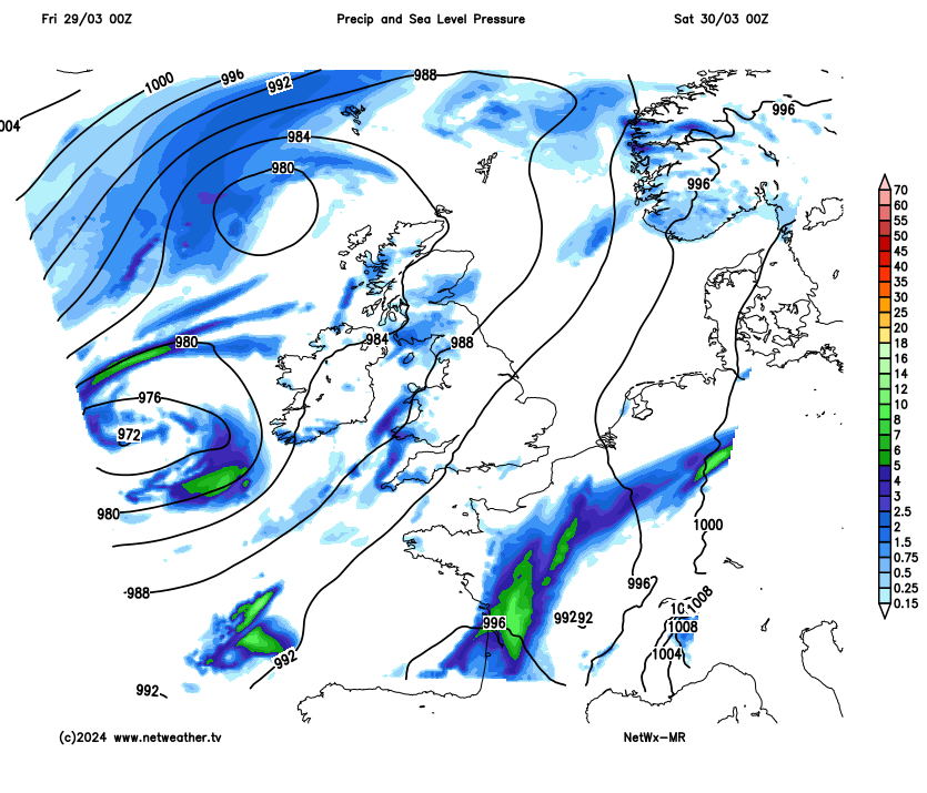
During Thursday, a deep surface low, named Storm Nelson by the Spanish Met Service, tracked northeast across Wales and northern England. The tight pressure gradient on the southeastern side of this low, as it moves northeast, produced strong winds across southern England . A top lowland Britain gust of 64mph at Plymouth, 61mph at Middle Wallop in Hampshire and Portland in Dorset, 59mph at Exeter.
In addition to the strong winds yesterday, cold mid-level temperatures produced by the cold-core of the upper low close to the west atop the moist S to SE surface flow – produced steep lapse rates and provided the instability on Thursday to support heavy downpours and scattered thunderstorms spreading northeast. A squally line of storms moved northeast through Dorset, Wiltshire and Oxfordshire and Northamptonshire during Thursday afternoon, with a possible supercell within the squall line, as evidenced by radar and also reports of large spiky hail from Oxfordshire around 3-4cm in diameter. The radar image for 4pm below shows strong radar echoes indicative of hail and radar signature of a potential supercell thunderstorm.
Good Friday remains breezy but with less in the way of heavy rain around than yesterday, but there are still some heavy showers around, some of which are producing thunder and lightning in the west so far, but these may also develop further east through the afternoon.
Fortunately, low pressure to the west looks to weaken over the weekend, so winds look to ease, showers should become more scattered and it looks to turn a little warmer. By Sunday we could see temperatures reach 16C in SE England, 11-13C in the north and west – where we saw snow yesterday! There will still be showers in the north and west on Saturday, some heavy, best chance of staying dry and the best of the sunshine across central, southern and eastern England. Easter Sunday mostly dry and sunny, just isolated showers in the west, perhaps cloudy towards the east coast though.
Easter Monday will see a change across the south, with a frontal system associated with an area of low pressure moving into the southwest approaches of the Atlantic pushing cloud and outbreaks of rain north across England and Wales, though tending to turn showery into the afternoon. Scotland looks to remain mostly dry and sunny though, but with a chilly easterly wind.
It looks to turn increasingly unsettled for the rest of next week, with a southerly tracking jet stream feeding in areas of low pressure across the UK. Initially spells of wet and windy weather or showers across England and Wales, but later in the week rain reaching Scotland too, where it may turn to snow over higher ground especially, as it meets colder air here.