
|
Summer 2007, what's going wrong? 19th July 2007 Compare the summer of 2007 to the summer of 2006 and the differences are huge, in 2006 by this time the highest temperature reached was 36.5°c on the 19th July in Surrey, so far this year 30°c has yet to be breached. In 2006 July was one of the warmest and sunniest in history, rainfall was below average as well, this year it seems likely that July may well end up being below average in temperature and well above average in terms of rainfall. What a difference a year can make! 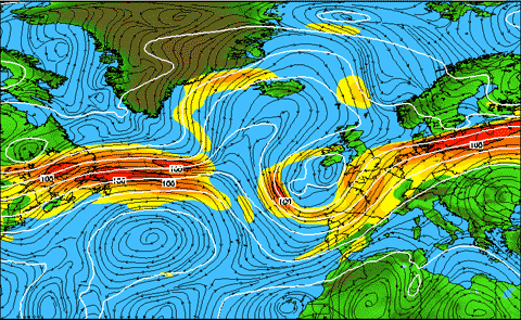 So what has caused this change in fortunes this year? Firstly it's important to note that recent summers have spoilt us in the UK with high temperatures and extended hot and dry periods, unsettled summer spells aren't uncommon but the flooding and ongoing nature of the unsettled weather this summer is quite exceptional.
On the chart alongside it shows the jetstream across the atlantic (yellows/oranges/reds), at this time of year it generally moves north of the British Isles to allow high pressure to build up across the country from the south and draw in warmer and generally drier air. This year the jetstream has persistently been right across of just south of the British Isles meaning high pressure hasn't been able to build and low pressure has almost always been close by. You can view the latest jetstream forecast on the chart viewer within the datacentre. For summer proper to start across the UK, keep watching for that movement of the jet northward. If you're planning to head to the Mediteranean for your summer holidays, the good news is that at the current time at least high pressure is managing to exert some influence there so you will be relieved to know you should see plenty in the way of sunshine and hot weather while you're there but keep tuned to the latest holiday forecasts as all the time that the jetstream is taking a southerly track it could get far enough south to bring some unsettled conditions into the Med. In the meantime expect further persistent rain and showers at times, with the added risk of storms in what is certainly becoming one of the most stormy summers in recent memory, and to think that this time last year the talk was about drought and water shortages...
|


